A five week plan for walking East 14th Street, made with four classmates at Columbia GSAPP
My roleMade the built environment maps for our report: transit, bikes, city policy, open space, trees and zoning
WhenSummer 2022, five weeks, 6 July to 5 August
WithLooper Planning, a team of five in Columbia GSAPP’s Introduction to Urban Planning
Run asFive report sections, one per person, on one shared base map
ScaleA 54 page report on East 14th Street, First Avenue to Avenue C
01
The question
What would make people slow down on East 14th Street? In 2022 the stretch between First Avenue and Avenue C had empty storefronts and heavy traffic, and gave people little reason to stay. Stuyvesant Town and Peter Cooper Village sit on the north side and the East Village on the south, and our report found a social and visual disconnect between the two sides. Our class was asked to plan how it could come back after the pandemic.
I went back on my own on 15 July with a camera and took about 200 photos. I wanted the maps to match what it felt like to stand there.
02
The hard part
Agreeing on the vision. Planning covers a lot of ground, and our team had ideas in all of it: linking up the green spaces, a community center open to everyone, and changing the zoning so buildings could hold community space, offices and affordable housing together. The vision statement went through five drafts over the course, and we had five weeks to pick one direction.
The two sides of the street also told different stories. When we split the census data at 14th Street, 40% of households on the Stuyvesant Town side made $150,000 or more a year, and the south side had a much more mixed rental market. People we talked to on the street said the East Village trash cans were always overflowing, and one said Stuyvesant Town does a good job policing itself.
What brokeAt the final review, the reviewers found our gray text hard to read. I muted everything outside the site, made the project area stand out, darkened the street names and added sources to each map.
03
How I ran it
The course set the deadlines. Inside them, we split the report so each person owned one section and could work in parallel.
- 7 to 15 July 2022First impressionsA first site visit with the class, then a photo walk on 15 July, about 200 pictures of the storefronts and sidewalks.
- 18 JulyMidterm site analysisThe street’s history, who has a say in it, what works and what does not, and what is there today. I pulled median household income and how people get to work, for 2010 and 2020.
- 20 to 25 JulyLearn from other streetsA second class visit on 20 July to watch the street and talk to people on it. Case studies, including a walk along the Hudson Street streetscape, and a reading of DOT’s own before and after reports on crosstown streets like 34th, 42nd and the M79.
- 28 July to 1 AugustNarrow the visionThe vision had already been through four drafts. On 28 July we refined it, and on 29 July we split the final report into five sections, one per person. Mine was the built environment.
- 5 AugustFinal report and panelsThe final presentation and two panels at the final review, with a 54 page report after.

We split the site into north and south sides by census tract, because the street divides the neighborhood and that let us map the gap.
04
What I built
My part of the report was the street as it is today, drawn on one shared base map. I made the subway, bus and bike maps, a map of city policies on the street (Vision Zero, the 14th Street busway and Open Streets), and maps of open space, community spaces, street trees, zoning and vacant storefronts, each with a page of notes and sources.
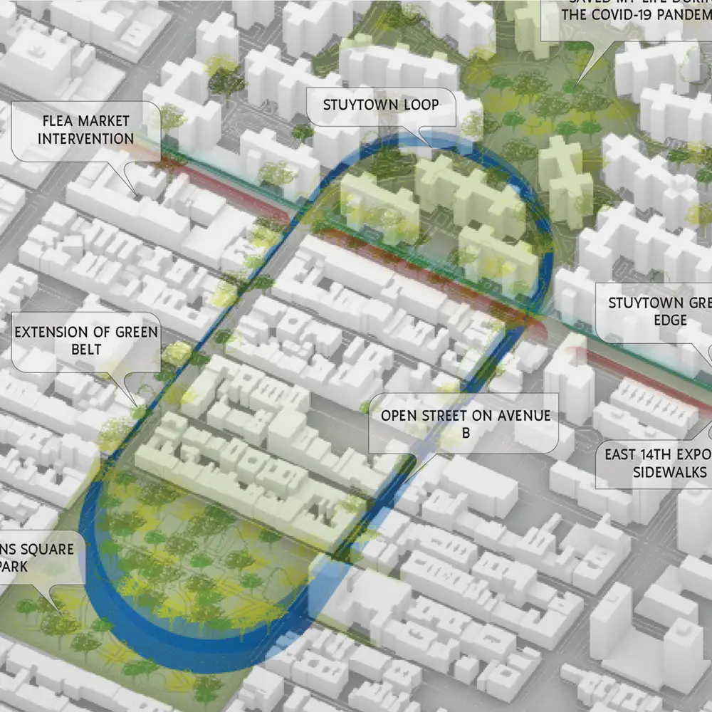
The team’s proposal is a “Green Loop”: a walking route that mirrors the loop inside Stuyvesant Town and carries it south to Tompkins Square Park, between Avenue A and Avenue C, joining up the green spaces that are already there.
The site analysis also pointed to the sidewalk around the First Avenue L station, used by nearly 21,000 people each weekday, as a place for benches, trees and tables.
Contact me to read the full report →
Adobe Illustrator · InDesign · Cadmapper · Lightroom · American Community Survey · MTA ridership data · NYC Open Data · ZoLa
We built on what is already there, like the Stuyvesant Town loop and the Avenue B Open Street, because extending those is easier to argue for.
We made room for the flea market vendors with low cost collapsible stalls, because they are people trying to earn a living.
05
What we proposed
- A Green Loop between Avenue A and Avenue C that joins the area’s existing green spaces and the Open Street on Avenue B, to connect the open space on both sides of 14th Street.
- Raised pavers along the loop, so the street surface itself slows cars down and guides people on foot.
- Habitable edges along the buildings, drawn from Jan Gehl’s ideas: spaces to linger.
- Modular stalls for the flea market vendors at Immaculate Church, so they can sell without blocking the sidewalk.

06
Where it went next
- The recommendations were presented to NYC DOT.
- At the final review, the critics pushed on who pays for the changes and who maintains them, and asked for a stronger link to flood risk after Hurricane Sandy.
- In my write-up for the course I said revitalization starts with a site analysis and with asking residents, business owners and visitors what they think.